How much water is in the snow below?
The amount of information Colorado water managers have about the state’s crucial snowpack is poised to swell exponentially over the next two years.
In mid-March, the Colorado Water Conservation Board, which aims to help water managers conserve, develop, protect and manage Colorado's water, approved a $1.9 million grant to help pay for a plane stuffed with high-tech equipment to fly over Colorado’s mountains and measure the snowpack below.
Denver Water used Airborne Snow Observatory, or ASO, flights in 2019 and 2021 to gather data on the snowpack above Dillon Reservoir, the utility’s largest reservoir.
The information helps forecast how much water is expected to come tumbling down the mountain during the spring runoff — a critical time for collecting and storing water for the utility’s 1.5 million water users across metro Denver.
“Getting more and better information about the snowpack improves the accuracy of our spring runoff forecasts, and that helps us in many ways,” said Nathan Elder, water supply manager for Denver Water.
Read how Denver Water monitors the snowpack in the watershed all year round.
“With better information, we have a better idea of how the spring runoff could impact the environment and recreation, and whether we might have to go on watering restrictions during the summer. It also helps inform us on how we should manage all of water resources,” he said.
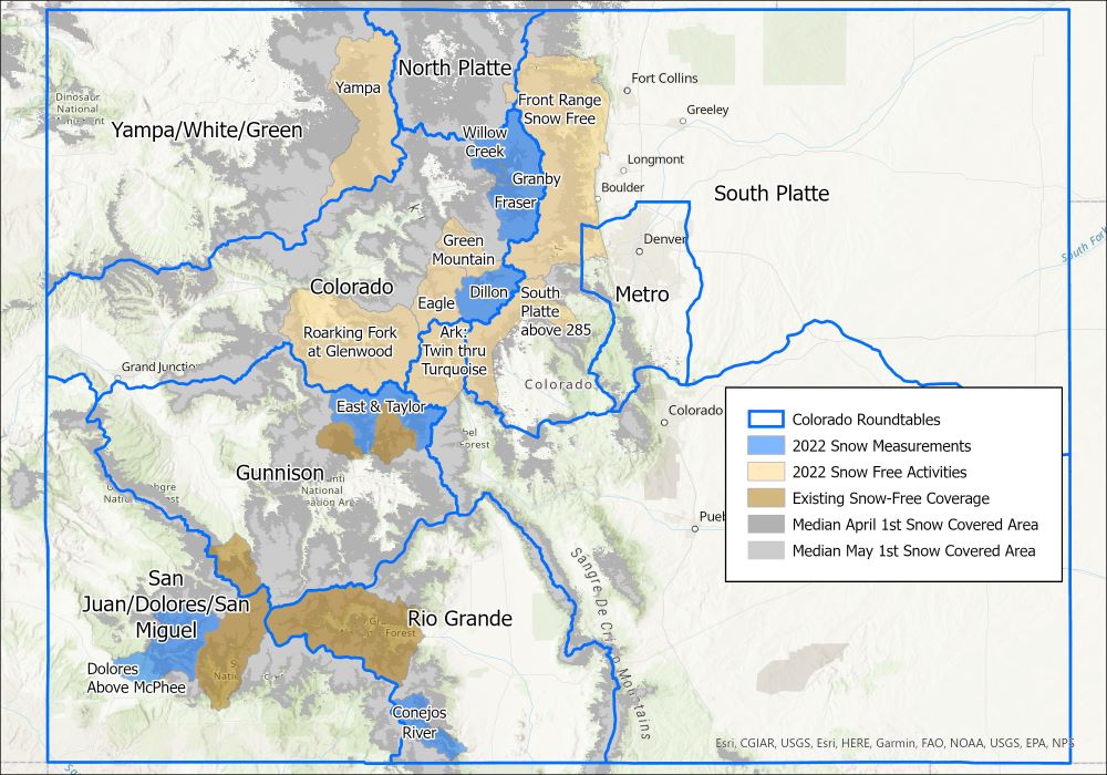
This year, in addition to getting ASO data about the snow in the Blue River Basin above Dillon, Denver Water also will get information about the snowpack in the Fraser, Granby and Willow Creek watersheds. Flights are scheduled for April and May, weather permitting.
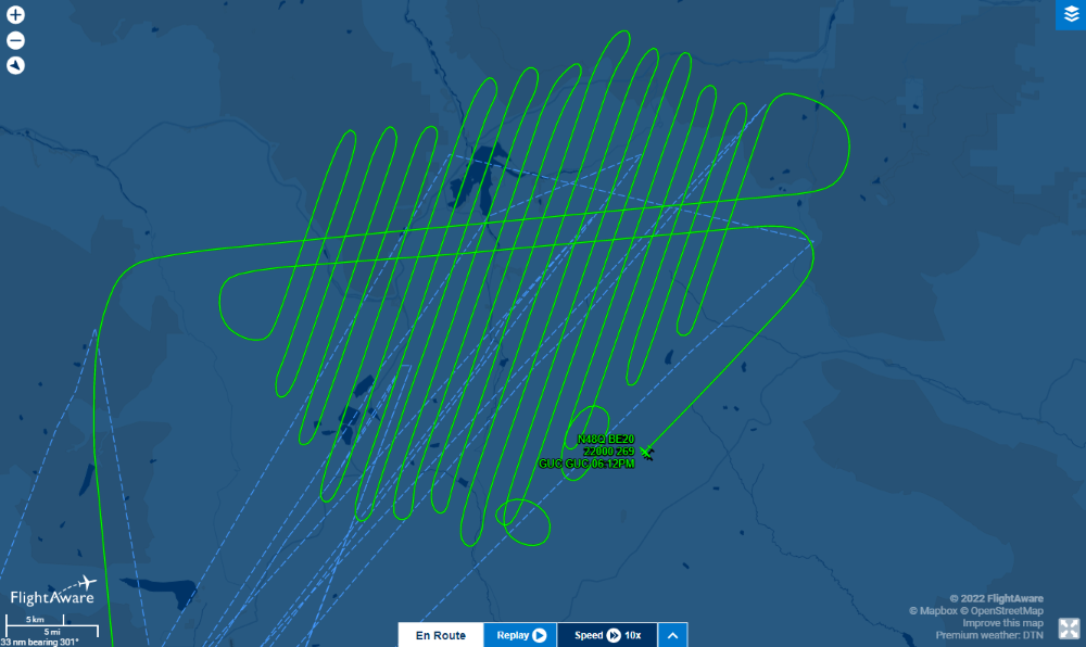
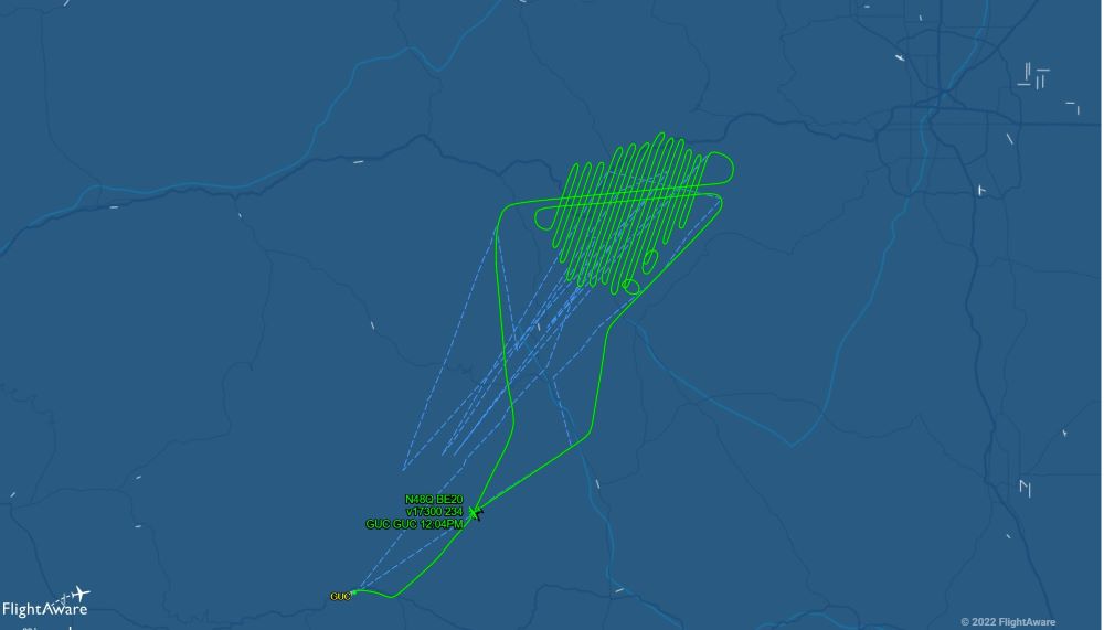
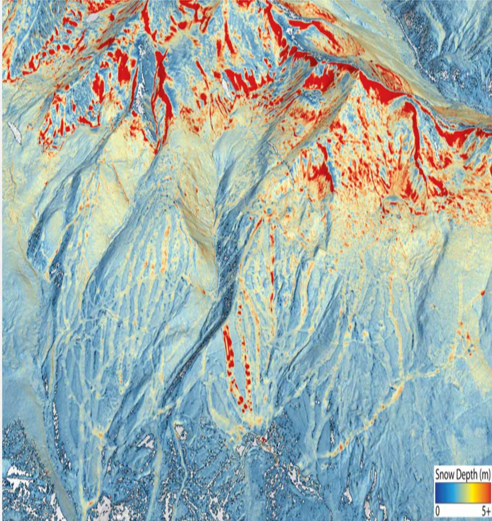
Based on NASA-developed technology, LiDAR equipment carried by the ASO planes use beams of light to measure the depth of the snow across entire watersheds and capture reflections from the frozen surface. Data from the flights over the snow-covered watersheds is compared to data collected when the same watershed is free of snow.
The resulting information from comparing the two sets of data tells water managers how much snow is on the ground and how much water it holds, augmenting data collected from SNOTEL sites, which also measure snowpack at selected sites, and decades of historical statistics.
“We see these ASO flights as a climate adaptation strategy,” said Taylor Winchell, a water resource engineer at Denver Water who works on climate change adaptation and water supply planning issues.
“As our snowpack changes with the changing climate, being better able to measure that snowpack becomes more important as more snow falls as rain, as the timing of the spring melt changes and as snow falls at ever-higher elevations because of warming. We can’t rely as much on historical snowpack datasets to understand the new snowpack reality.”
Winchell worked with water managers throughout Colorado to develop support for the state grant and create a collective known as CASM, short for the Colorado Airborne Snow Measurement group, that grew to include members from federal, state and local government levels, academia, the recreation industry and agriculture industries, as well as local nonprofits and environmental advocacy organizations.
“We had 37 letters of support for the initiative. To have that many groups supporting a water project, that’s unprecedented for a water project in Colorado. It’s rare to see so many people agree on something — but more accurate data helps everyone,” Winchell said.
In addition to flights over snow-covered mountain watersheds, the grant also will help pay for flights over snow-free ground — collecting essential baseline information that can be used to expand the snow-on flight areas even more next year and beyond, Winchell said.
Work also will be underway this year to figure out how to continue the CASM program in the future, as the state’s grant is a one-year grant, Winchell said.
Denver Water managers are looking forward to seeing more ASO information about its watersheds, and also those throughout the state.
“How much snow falls outside our watersheds can affect Denver Water’s supply and operations just like the amount of snow that falls inside our watersheds,” Elder said.
“With this starting to become a statewide program, with data collected from more areas and that data being shared among the partners, it will help everyone better manage Colorado’s water supply.”