News Article
Living up to the La Nina hype
Projected weather pattern promised a drier winter for much of Colorado. And so far, so dry.
Weather forecasters take a lot of grief when they’re wrong. So let’s give proper credit to the many who accurately predicted a strong La Nina weather pattern for Colorado this winter.
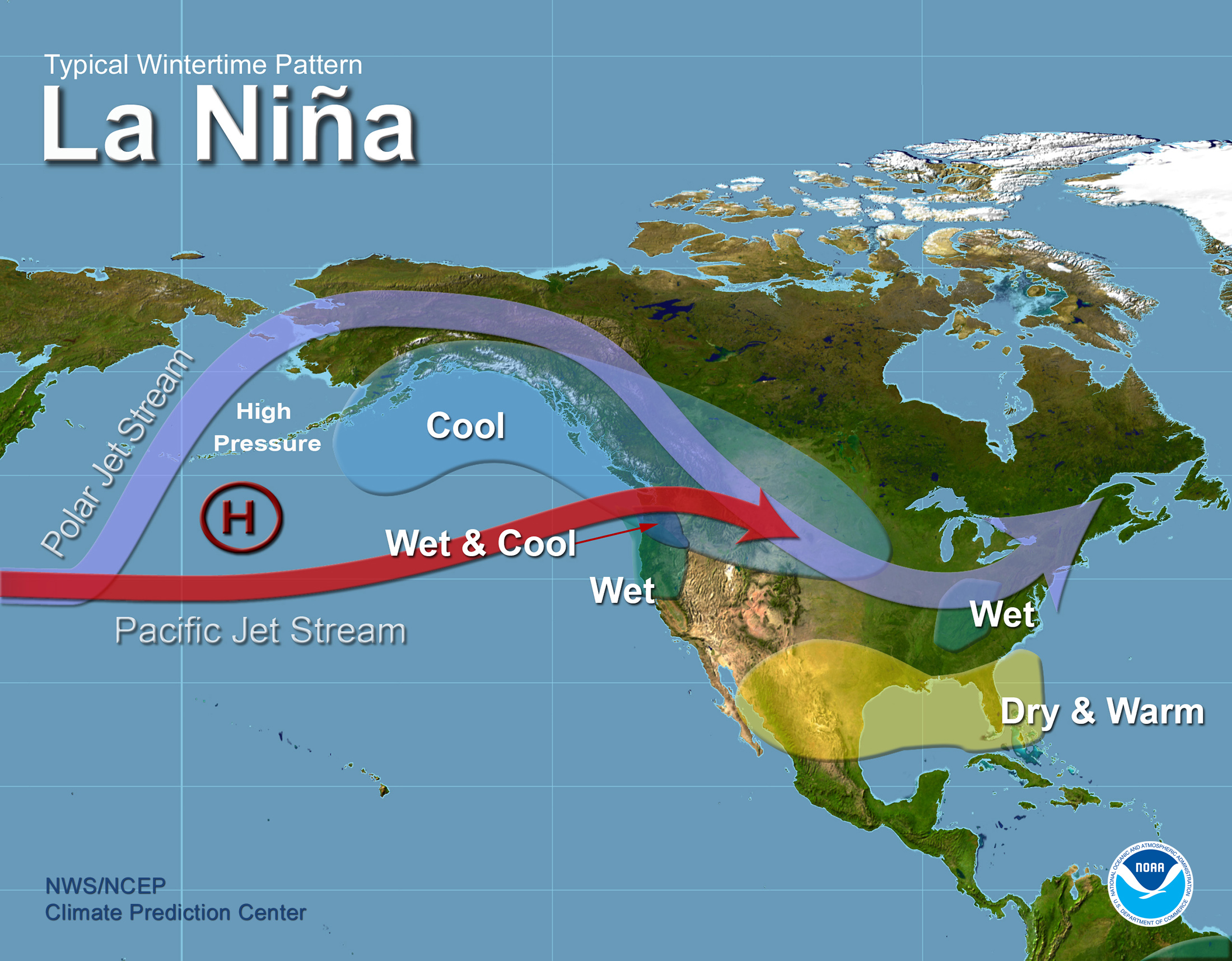
La Nina is the presence of cooler-than-usual sea-surface temperatures in the central Pacific Ocean. For Colorado, this often means more snow for the northern mountains in the state, but drier conditions in the southern part as the jet stream tends to push major weather patterns further north.
Sound familiar?
Looking at the state’s most recent snow water equivalent map, and it shows La Nina has lived up to her reputation. More snow in the northern mountains, and alarmingly low levels in the south, particularly in the southwestern corner of the state.
For Denver Water customers, that map is relatively good news. We get our water supply from sections of the South Platte and Colorado river basins, which have seen relatively decent snowfall during this La Nina spell. Our reservoir levels are in good shape for this time of year as well, sitting at 89 percent of capacity against a historic median of 80 percent.
“Certainly it’s been drier than we’d like to see this winter,” said Nathan Elder, a senior water resource engineer at Denver Water. “But the snowpack levels in the river basins we monitor are still good. And we’ve had a few seasons of wet weather to help build our reservoir levels. Overall, Denver Water customers should feel comfortable with where we are right now.”
However, the statewide snowpack level sits at just 73 percent. It’s dragged down by the lower totals in the southwest mountains of Colorado. But changes may be on the way. The National Oceanic and Atmospheric Administration released its monthly forecast, calling for La Nina conditions to weaken by spring and move toward a more neutral weather pattern (“ENSO neutral” if you really want to go down a rabbit hole).
But NOAA’s three-month temperature and precipitation forecasts may not carry good news. The forecast map predicts above-average temperatures and below-average precipitation for much of Colorado for March, April and May. That’s not ideal weather for accumulating snowpack.
“Typically, March is the snowiest month of the year in our collection areas,” said Elder. “March and April are always a critical time of year for watching the snowpack. We’re in good shape now, but things can change quickly this time of year.”
Here’s hoping forecasters only bat .500 for the winter, and we see milder temperatures with more moisture this spring. To all the meteorologists out there, we promise not to hold it against you if you’re wrong this time. We’re kind of rooting for it.